Grow your Business
at the Launchpad
232 South Main Street
Phone 574-533-2102
or
We Have Your Welcome Home!
Shipshewana
1/4 mile south & 1/4 mile
east of Junction 5 & 20
Store Hours
Mon - Fri 9-5; Sat 9-4
Closed Sunday
Mattresses, Living Room, Dining Room,
Bedroom, Office, Home Décor and More!
260.768.7730 - WeaverFurnitureSales.com
P
alm
S
unday
T
ornadoes
| 50
th
A
nniversary
4
| Saturday, April 11, 2015 The Goshen News
W
hat
H
appened
T
hat
D
ay
?
The anatomy of disaster
z
Weather experts
recount how deadly
twisters formed
By ROGER SCHNEIDER
NORTH WEBSTER —
Michael Lewis likes to talk
weather. It’s his passion and
livelihood as warning coordi-
nation meteorologist of the
National Weather Service of-
fice in North Webster. When
talk turns to the 1965 Palm
Sunday outbreak, he grabs
worn copies of weather
science booklets that define
that outbreak and many
outbreaks since then.
University of Chicago Pro-
fessor Tetsuya Theodore Fu-
jita, simply known as “Ted”
in the weather service field,
authored the booklets. He
also created the Fujita Scale
in 1971 that assesses the
strength of tornadoes. The
scale runs from the weakest
F0 tornado to the strongest
F5. The scale was revised in
2007 and is now known as
the Enhanced Fujita Scale.
Fujita visited Elkhart
County after the 1965 out-
break and with fellow Pro-
fessor Dorothy L. Bradbury
and C.F. Van Thullenar of
the National Severe Storms
Forecast Center, wrote in
1970 a landmark scientific
paper, complete with graphs,
charts and mathematical
formulas about how the
tornadoes were spawned
and acted once they touched
down.
Lewis boiled Fujita’s docu-
ment down to plain English.
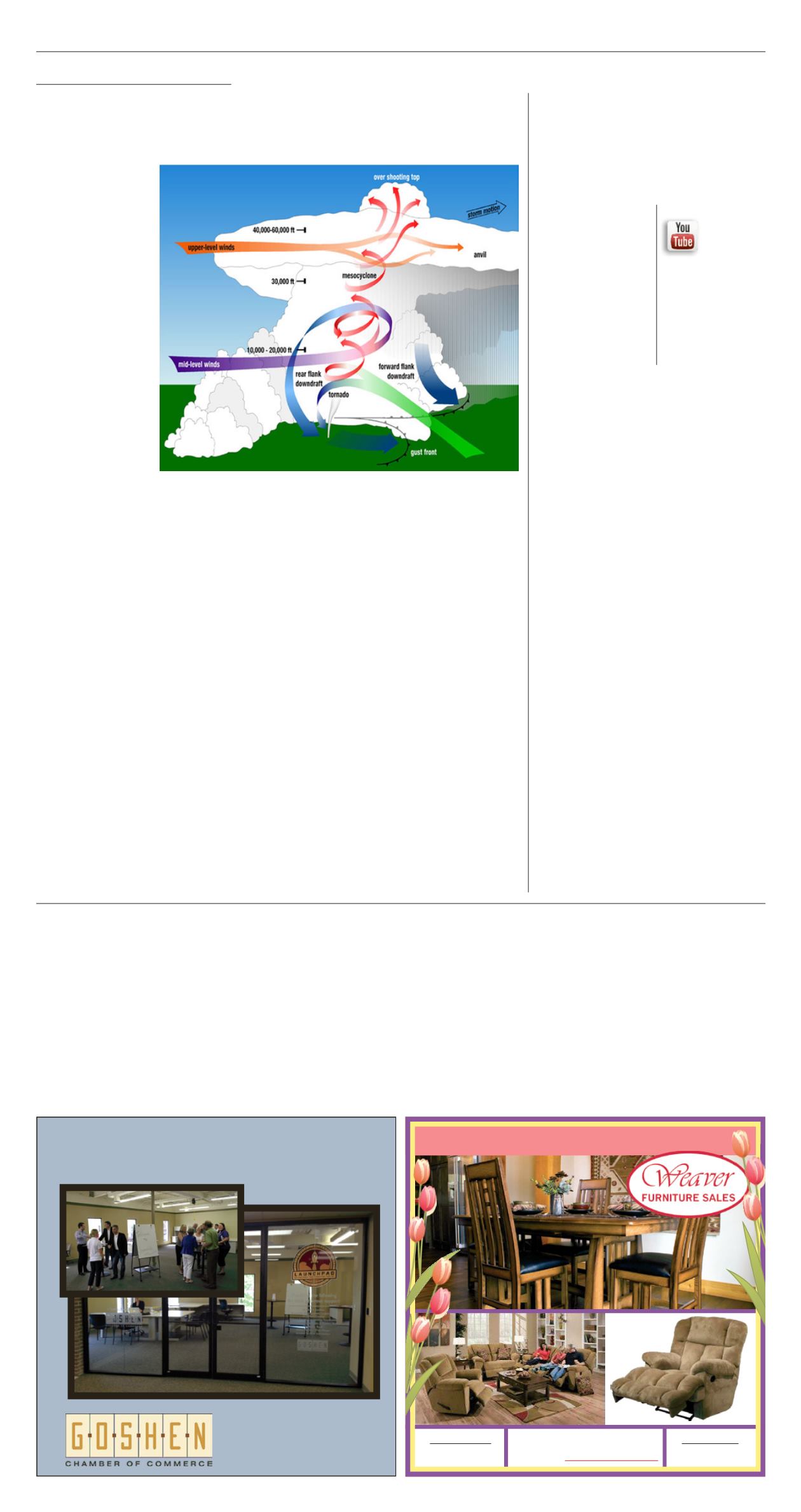
“Those are big, long-
lived supercell storms,”
Lewis said of the 1965
Palm Sunday tornadoes.
“Supercells are individual
thunderstorms that develop
in an environment where
the moisture and warm air
is in place. There usually is
a good southernly flow of
warm air coming in to the
base of the storm and as you
go up in the atmosphere, the
colder air is coming in but
the direction of the winds
changes in height, in such
that when the storm begins
to develop, it begins to twist
and turn or rotate. When
you get to that set of condi-
tions that are ideal for a
rotating updraft, you have a
storm that can sustain itself.
“The updraft will ride
up into the storm,” he
continued. “But then the
downdraft will begin to wrap
around and act as a bulldoz-
er beginning to push more
moist air into the storm. So
you end up with the whole
updraft, downdraft kind of
rotating around itself.”
Such long-lasting torna-
does formed four times on
April 11, 1965 and struck
Elkhart County.
The tornadoes
Four tornadoes touched
down in Elkhart County.
Three have been rated F4
after years of review and
one is rated an F3. All were
deadly.
The tornado that de-
stroyed the Sunnyside and
Kingston Heights subdivi-
sions on the north edge of
Dunlap was once rated an
F5, but was downgraded on
the Fujita scale, according
to the National Weather
Service.
All four of the tornadoes
were long lived and three
of them formed well to the
west of Goshen in Marshall
or St. Joseph counties.
Only the F4 twister that
killed people near Shipshe-
wana spawned in Elkhart
County. That tornado
formed just east of Ind. 13,
several miles south of Mid-
dlebury. Witnesses reported
they saw a tornado touch
down briefly at the Goshen
dam and then rise over the
hospital. Local speculation is
that the Goshen tornado cell
may have reformed along
Ind. 13.
Big and rare
The Palm Sunday torna-
does were rare occurrences
in several aspects. First, tor-
nadoes themselves are very
rare. Of the average 100,000
thunderstorms produced
each year in the United
States, only 800 result in
tornadoes, according to the
National Oceanic and Atmo-
spheric Administration.
Supercell storms are even
less frequent, but produce
most of the deadly torna-
does.
The F3 and F4 tornadoes
are among the rarest forms
of tornadoes. The National
Weather Service estimates
that just 6 percent of all tor-
nadoes in the United States
reach the F3 size.
“It’s also important to
remember that EF4 and EF5
tornadoes are extremely
rare,” said Ball State meteo-
rology Professor David Call.
“Only one F5/EF5 tornado
has ever occurred in Indi-
ana, and there were no EF5
tornadoes nationwide in
2014, 2012, 2010, 2009 and
the years 2000-2006 inclu-
sive.”
Figuring the odds of hav-
ing an outbreak of three F4
storms in Elkhart County
might overwhelm the best
of statisticians. Just 2 per-
cent of all tornadoes reach
the catastrophic F4 size,
according to the NWS.
Why here?
For three F4s and an F3
to form and travel along the
same general path, favorable
weather conditions have to
exist and linger. And the un-
seasonable warm tempera-
tures on Palm Sunday 1965,
coupled with high humidity
and an approaching cold
front from the west, were
perfect conditions for big
storms to form.
graphic provided
This graphic provided
by the National Weather Service shows the atmo-
spheric conditions that are most likely to form a tornado.
The report from the U.S. Weather
Bureau for the area on April 11, 1965
z
Noon —
“Call from Chicago to South
Bend that a deep low is located over
Central Iowa, extending into Texas,
while a warm front extended east
into Northern Indiana. This clash of
fronts results in a severe thunderstorm
and tornado forecast until 7 p.m. for
areas west of St. Louis to north of
Indianapolis.”
z
5:30 p.m. —
“Radar shows hook
echo or possible tornado just west of
Knox and in the vicinity of Michigan
City. A warning is issued to all counties
in Northern Indiana and Southern
Michigan.”
z
5:43 p.m. —
“Severe thunderstorm
and tornado warning. Radar indicates
some very strong storm echoes in
Starke County, moving northeast.”
z
5:56 p.m. —
“Phone call from
Indiana State Police reporting tornado
on the ground near Koontz Lake
and another between Plymouth and
Hamlet.”
z
5:58 p.m. —
“Phone call from
marshal of Argos, reporting tornado in
vicinity of Donaldson on U.S. 30 and
moving northeast.”
z
6 p.m. —
“Persons in Marshall,
St. Joseph, Elkhart and Kosciusko
counties should take emergency
precautions due to approaching
tornadoes.”
z
6:24 p.m. —
“More tornadoes
sighted 15 miles west of Plymouth and
four miles west of Nappanee.”
z
6:28 p.m. —
“Tornadoes sighted
near Hebron, two miles south of
Kingsford Heights, three miles south of
Union and five miles west of Goshen.”
z
6:50 p.m. —
“Reports of tornadoes
and funnel clouds have become so
numerous that we are issuing a blanket
warning for all of Northern Indiana.”
z
7:04 p.m. —
“Funnel southeast
of Mishawaka near television hill;
hailstones of one-and-a-half inches at
the South Bend Airport.
z
7:10 p.m. —
“Tornado just west of
Bremen and another over U.S. 31 and
New Road.”
z
7:33 p.m. —
“Partial all clear
statement. Squall line 45 miles north of
Terre Haute to Kalamazoo to 55 miles
west of Saginaw. Threat of tornadoes
now over for west of these locations.”
z
8:30 p.m. —
“All clear statement.”
WEATHER NOTES
z
Lawrence A. Schaal, climatologist at
Purdue, made an aerial inspection of
the areas hardest hit. His estimate was
that some tornado wind speeds were
between 500 and 600 miles per hour,
five times above average.
z
Some tornadoes were as much
as a mile wide and it is believed
five tornadoes were striking Indiana
simultaneously in the early evening.
z
The temperature dropped from 73
before the storms to 64 after and the
humidity plunged from 76 to 36.
z
The longest officially recorded
tornado traveled 293 miles through
Illinois and Indiana on May 26, 1917.
It was on the ground seven hours, 20
minutes.
From the U.S. Weather Bureau
See
DISASTER
| 29
Warning systems
have come a long
way since 1965
By DANIEL RIORDAN
GOSHEN— Some
people in Elkhart County
sat at home on their
porches hoping to catch a
cool breeze on an unsea-
sonably hot day. Young
couples prepared to go on
dates. Children played tag
outside. Others flocked to
local golf courses to get an
early round in.
It was April 11, 1965.
Palm Sunday. On the Chris-
tian calendar, this holy day
marks Jesus’ triumphant
journey into Jerusalem. In
five days, Christians would
mark his death on Good
Friday and then his resur-
rection two days later.
Later that day, death
and destruction shrouded
Elkhart County communi-
ties in prayer and contem-
plation normally reserved
for the feast of Easter.
By the accounts of
meteorologists, there was
no way to predict where
those tornadoes would hit
with any sort of accuracy.
The key tools of those days
were crude radar bor-
rowed from bigger cities,
including Detroit and Chi-
cago. The Storm Prediction
Center in Norman, Okla-
homa, was still 30 years
from being formed when
tornadoes leveled parts
of LaGrange and Elkhart
counties in 1965.
Emergency manage-
ment director positions
were created in the wake of
September 11, 2001 terror-
ist attacks.
“A lot of the response
that would happen now,”
said Mike Pennington, “is
a result in the advance in
technology.”
Pennington is the deputy
director of the Elkhart
County Emergency Man-
agement Agency.
“From then to now
there’s just more training
and push for people to
make a plan,” he said. “We
have weather radios. Now
Goshen has 16 tornado
sirens.”
In 1965, the tornado re-
sponse due to technology
was almost purely reactive.
Today, the Storm Predic-
tion Center in Norman,
Oklahoma can issue haz-
ardous weather outlooks
for an area days in advance.
“Back then they could
only see the storms them-
selves,” said Nick Green-
awalt, meteorologist for the
National Weather Service
near North Webster, of the
response in 1965. “Now
we can see what’s in the
storms. And we can really
pinpoint when a storm will
hit.”
Last week, Greenawalt
and staff at the North
Webster office were moni-
toring a chance for severe
weather later in the week.
“We really use the ready,
set, go mentality,” Green-
awalt said. “In the days
leading up to a potential
event it’s ready. The set
is the watch phase. Once
we see a storm we’ll issue
a warning for that storm
specifically. That’s the go
phase.”
TV involvement
“All of the TV stations
use the same radar data,”
WNDU meteorologist
Mike Hoffman said. “We
just call it different things.
But what it does is allows
us to peer into a storm and
see what’s going on.”
Hoffman explained that
if severe weather is get-
ting ready to hit the area,
he’ll provide continuous
updates on TV. While Hoff-
man is on the air, meteo-
Video
WNDU
Meteorologist
Mike Hoffman
describes the
Palm Sunday tornadoes
at youtube.com/user/
thegoshennews
Inside
What forecasting and
warning lessons did we
learn from April 11, 1965?
PAGE 15
See
Warning
| 15


